
Satellite Image Ancient Observatories
Below are satellite images of ancient observatories from around the world. These satellite images are made possible by cutting-edge satellite technology. By using the latest remote sensing technology, we are able to display these long-lost observatory sites from around the world.
Satellite imagery combined with GIS maps is essential for habitat and vegetation and coastal mapping, monitoring, assessment, and analysis of the progression of conservation activities, ecological patterns, encroachment of protected wildlife parks, monitoring of wildlife, and building management support systems by comparing images from different dates
Angkor Wat – Cambodia
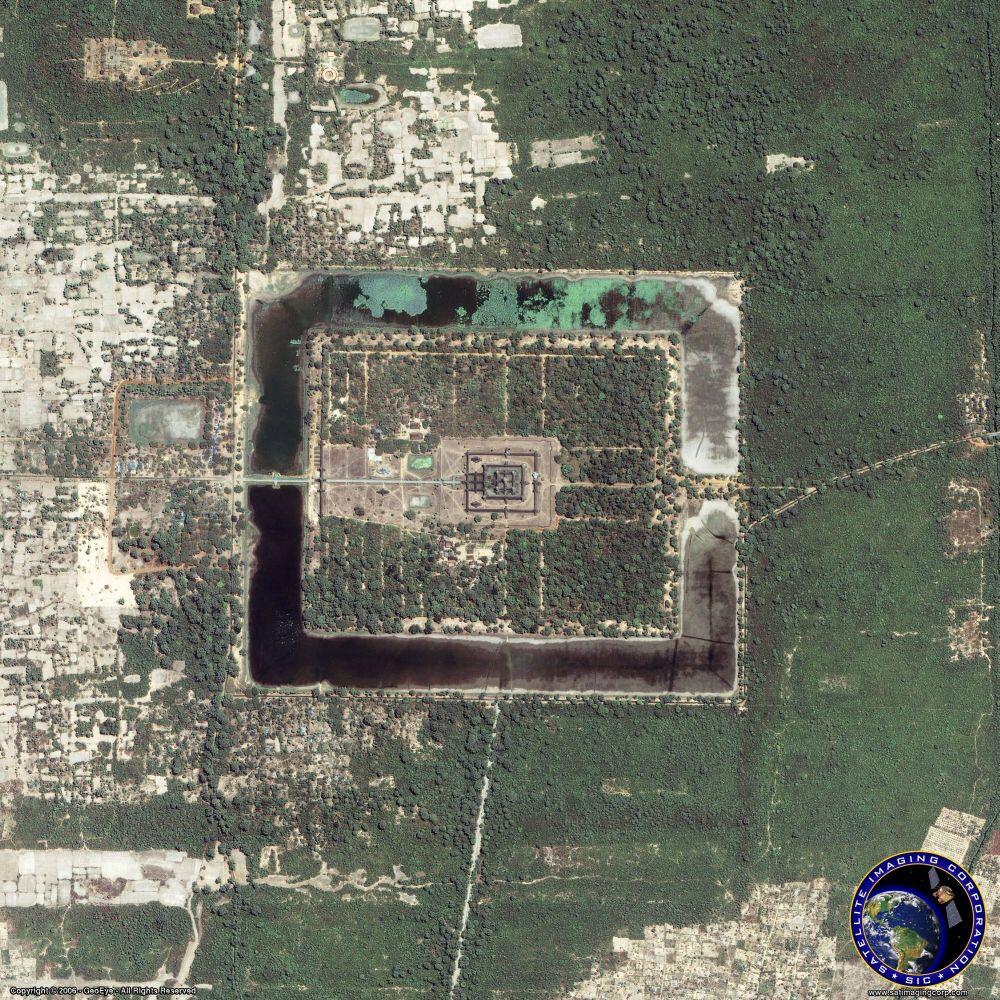
Photo credit: MAXAR.
Created as a constant reminder of a greater cosmic order, Angkor Wat shows several apparent solar alignments with a nearby mountaintop shrine. A person standing at Pre Rup, six kilometers away, could watch the sunset over Angkor Wat at the winter solstice. A person standing in the southwestern corner of the temple could watch the rising sun through the eastern gate during the summer solstice.
Casa Rinconada – New Mexico, United States

Photo credit: MAXAR
Casa Rinconada, built between 1070 and 1110 AD, sits on an isolated hill about one-half mile across the canyon from Pueblo Bonito. One of the six great community kivas in the area, the structure is about 20 meters across and four to five meters deep. A 1970s survey of the area found this site to have precise solstice and equinox alignments. The main axis of the kiva is aligned through doorways on both the north and south sides. Modeled on a perfect circle, niches in the interior form an east-west line. Scientists who measured the alignments of these features found the accuracy of the north-south alignment to be within 45 arc-seconds or three-quarters of a degree while the error in the east-west alignment is only eight arc-seconds. Solar alignments occur on the winter and summer solstices when sunlight entering the kiva falls upon one of six irregular niches. From a given niche, the sun framed in the narrow window could be seen.
Chankillo — Peru

Photo credit: MAXAR
About 400 kilometers (250 miles) north of Lima, Peru, lies an enigmatic, 2,300-year-old observatory named Chankillo on January 13, 2002, the central complex appears in the upper left with its concentric rings of fortified walls. The Thirteen Towers (Southeast of the central complex) were the key to the scientist’s conclusion that the site was a solar observatory. These regularly spaced towers line up along a hill, separated by about 5 meters (16 feet). The towers are easily seen from Chankillo’s central complex, but the views of these towers from the eastern and western observing points are especially illuminating. Although the dark shapes in the northeast seem like rock outcrops, they are actually trees. These viewpoints are situated so that, on the winter and summer solstices, the sunrises and sunsets line up with the towers at either end of the line. Other solar events, such as the rising and setting of the Sun at the mid-points between the solstices, were aligned with different towers.
Chichen Itza — Mexico

Photo credit: MAXAR
In a spectacular show of shadow and light, a shadow representing the Feathered Serpent god Kukulkan slides down the northern stairway of Chichen Itza during the sunset of the equinoxes and then vanishes. The square, stepped pyramid, built by Mayans in about 1000 to 1200 AD also has axes that orient with the rising point of the sun at the summer solstice and setting point during the winter solstice. Many think the pyramid also serves as a calendar. Each of the four faces of the pyramid has a stairway with 91 steps. With the addition of a shared step forming a platform at the top, this totals 365, the number of days in a year. The stairways also divide the nine terraces on each side into 18 segments, representing the 18 months of the Mayan calendar.
Dzibilchaltun — Mexico

Photo credit: MAXAR
The highlight of Dzibilchaltun, or “Place of Stone Writing,” is watching the equinox sunrise through a door of the Temple of Seven Dolls. The Mayan city, first built in 300 BC, was occupied when the Spaniards discovered the city.
Easter Island — Chile

Photo credit: MAXAR
Called the Navel of the World, Easter Island is home to over a half-dozen volcanoes and more than 880 statues called moai (pronounced mo-eye). Ranging from just a few feet to more than 30 feet tall, the enigmatic statues weigh up to 150 tons. They were hewn from volcanic material from quarries on the slopes of the Rano Raraku volcano sometime after 300 AD. While nearly all of the moai face toward the interior of the island, seven moai at Aku Akivi, not shown in the image, face towards the ocean and a point on the horizon where the sun sets during the equinox. Explorer, Captain James Cook gave the island its modern name in 1774.
Machu Picchu — Peru

Photo credit: MAXAR
One of the most famous Incan cities in the world, sun alignments are found throughout Machu Picchu. Many features, including the Sacred Plaza, The Temple of Three Windows, and the Intihuatana platform, align with the summer solstice azimuth of 65-245 degrees. Scientists believe these alignments were primary considerations in the construction of the shrines. A shaft of light, shining through an east-facing window, reportedly illuminates The Torreon, or Temple of the Sun, during the summer solstice. The city was built between 1460 and 1470 AD at an altitude of 8,000 feet.
Mayapan — Mexico

Photo credit: MAXAR
Mayapan, reaching its zenith around 1200 AD, represents one of the largest assemblages of Mayan ruins in the Yucatan and is one of the few walled Mayan cities. The largest pyramid is the Castle of Kukulkan, made as a smaller replica of the Castle of Chichen Itza. Mayapan also is home to many circular buildings or observatories. The Mayans astronomical knowledge helped them predict the exact time of solar and planetary events and aided in the creation of precise calendars.
Stonehenge — United Kingdom

Photo credit: MAXAR
Possibly the world’s most recognized ancient observatory, Stonehenge’s Ring of Stones was built more than 5000 years ago on a wind-swept hill near Salisbury, United Kingdom. Recent theories support construction in about 2000 BC by a late Neolithic people known as the Beakers. Their addition to the project included adding a double ring of stones inside the original earthen henge. More than 80 “bluestones,” some weighing up to four tons, were transported several hundred miles from quarries in Wales. Controversy surrounds some of the possible stellar alignments at Stonehenge, but on the longest day of the year, the summer solstice, the rising sun does appear behind the “Heel Stone.” As the sun rises, the shadow cast by the Heel Stone creeps up the length of the rock and into the heart of the five interior “sarsen” pillar stones.
Teotihuacan — Mexico

Photo credit: MAXAR
Rising 20 stories above the central Mexican highlands, the pyramids of Teotihuacan (pronounced tay-oh-tee-wah-con) were central to Toltec learning and culture. The city, about the size of ancient Athens and Rome, was abandoned about 1500 years ago. Using an advanced understanding of mathematics, geometry, and astronomy, the Toltecs built the largest pyramid, “The Pyramid of the Sun,” with an alignment to coincide with the two days (May 19th and July 25th) when the sun would be directly over the top of the pyramid at noon. This would also create an alignment to the east toward the rising sun and to the west toward the setting sun. This pyramid has a base only 10 feet shorter on each side than the Great Pyramid of Cheops in Egypt.
Uxmal — Mexico

Photo credit: MAXAR
Founded in about 500 AD, Uxmal (pronounced “oosh-mahl”) was the most powerful site in western Yucatan. Many of the buildings rely simply on well-cut stones with no mortar. Astronomical alignments at Uxmal surround the planet Venus. The orientation of the long Palace of the Governor acts as a sighting with other buildings at Uxmal pointing to the southernmost rise location of Venus, which occurs once every eight years.