
Satellite Images to Determine City’s True Hot Spots
According to a recent article in the Chicago Sun-Times, the Chicago Planning Department recently used satellite image data to determine the city’s “hottest” areas. Not to be confused with popular neighborhoods or trendy locations, this type of “heat” is the real kind – based on both daytime and nighttime temperatures.
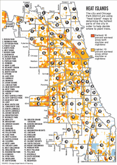
The goal of the study was to determine the overall effect that “dark” structures, such as tar roofs, and asphalt parking lots, are having on the temperatures in various parts of the city – and what can be done to lower those temperatures.
The methodology used by the city was simple:
To perform the Chicago analysis, two Landsat 7 satellite images were used — one captured on a morning in September 2001 and another at night in May 2005. The satellites captured surface temps, not air temps, said Anne Jaluzot, a city urban planner.
Following is the image produced by merging the data from the daytime and nighttime temperature images:
Here’s a link to the PDF version of the map from the Sun-Times site.
File the Chicago Planning Department’s project in the growing folder of ways to use satellite imagery to enhance urban planning projects to improve the lives of citizens.
Satellite Imaging Corporation offers full Landsat imaging services from the Landsat 7 satellite sensor. If your project would benefit from advanced satellite thermal imagery, check out our client list, look at our satellite imaging services, or contact us today to describe your needs.