
Machine Learning and Remote Sensing Technology
Machine Learning (ML) and remote sensing technology aid in many applications requiring large amounts of spectral and spatial data needed for pattern recognition. ML uses algorithms through computer systems, computer vision, and deep learning methods to collect and identify features in an environment with precise accuracy and speed. ML a subdivision of Artificial Intelligence (AI) and Computer Vision (CV) can help the end-user to understand the data collected in order to find resolutions for remote sensing data and improve the overall accuracy of the data classification and can enhance the reliability and assessment of the features of data collected. ML algorithms through neural networks can improve the analysis of large areas to classify objects, identify temporal change, data fusion, cloud removal, and spectral analysis from satellite or aerial imagery that will overcome the challenges of remote sensing data.
Images collected by satellites or unmanned aerial vehicles (UAV) by applying ML techniques, these models can provide near real-time reports for areas with complex feature distribution such as in the applications of environmental monitoring and management, mineral mapping, agriculture, disaster management, climate change, and wildlife conservation.
WorldView-3 SWIR Satellite Image of Geological Interpretation (30cm)
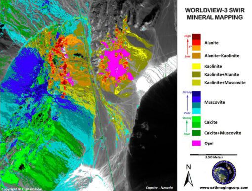
Image credit: MAXAR. All rights reserved.