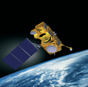
Sentinel-3 Satellite Launch
Sentinel-3 satellite which is scheduled to launch in 2013 is the third in a series of five space missions European Space Agency (ESA) is developing for the Global Monitoring for Environment and Security (GMES) initiative. The mission’s main objective is to determine the parameters of sea-surface topography, sea and land surface temperature as well as ocean and land surface color.
Sentinel-3 satellite will support services related to the marine environment, such as maritime safety services that need ocean surface-wave information, ocean-current forecasting services that need surface-temperature information, and sea-water quality and pollution monitoring services that require advanced ocean color products from both the open ocean and coastal areas.
Sentinel 3 Satellite Sensor

Image Credit: ESA
The mission’s optical sensors will comprise an Ocean Land Color Instrument (OLCI), which is based on Envisat’s Medium Resolution Imaging Spectrometer (MERIS), and a Sea-Land Surface Temperature Radiometer (SLSTR), which is a successor to Envisat’s Advanced Along Track Scanning Radiometer (AATSR). Sentinel-3 will serve numerous land, atmospheric, and cryospheric application areas such as land-use change monitoring, forest cover mapping, and fire detection.
The high-inclination orbit of Sentinel-3 brings the added benefit of routine altimetric observations of marine and land ice in the Arctic and Antarctic high-latitude regions. GMES Sentinel-3 shall provide continuity to the high-resolution along-track marine and land ice surface measurements of CryoSat, and shall result in the continued ability to derive sea-ice thickness and ice sheet topography from elevation profiles.

